The Landform of Taiwan
Relevant Websites
- Xue-sheng-zuo-ye
- Reng-shi-tai-wan-di-li-pian, wang-lujiao-xue-zi-yuan
- Ye-liu-he-ping-daozhi-xing-zhi-lu <<ye-wai-shi-cha-shou-ce>> (Tai-wan-de-di-xing)
- Tai-wan-shan-tue-jian-jie
Reference
- Lin, Chao-chi, 1957: Tai-wan-di-xing, Tai-wan-sheng-wen-xian-wei-yuan-hui, p. 424.
- Shih, Tsai-tien, 1970: Tai-wan-bei-bu-hai-an-de-di-xing-xue-ji-liang-yan-jiu, Department of Geography - National Taiwan Normal University, p.52.
- Shih, Tsai-tien, 1972: Taiwan-di-xing-qi-quan, Zhong-yang-yue-gan, Vol.4 - 3, pp. 173-180.
- Shih, Tsai-tien, 1973: Tai-wan-hai-an-qi-quan, Zhong-yang-yue-gan, Vol.5 - 7, pp. 177-185.
- Shih, Tsai-tien, 1979: Tai-wan-xi-nan-bu-zhou-xie-hai-an-de-di-xing-ji-qi-yan-bian, Shi-da-di-li-yan-jiu-bao-gao, Vol. 5, pp.11-48.
- Shih, Tsai-tien, 1980: Tai-wan-xi-bu-hai-an-xian-de-yan-bian-ji-hai-pu-xin-sheng-di-kai-fa, Shi-da-di-li-yan-jiu-bao-gao, Vol. 6, pp.1-36.
- Shih, Tsai-tien, Jui-chin Chang, Cheng-liang Chang, Hsueh-mei Lin and Chen-ching Lien, 1992: Tai-wan-bei-bu-hai-hai-an-sha-qiu-zhi-di-xin-xue-yan-jiu, Shi-da-di-li-yan-jiu-bao-gao, Vol. 18, pp.193-240.
- Shih, Tsai-tien, Jui-chin Chang, Cheng-liang Chang, Hsueh-mei Lin and Chen-ching Lien, 1993: Tai-wan-xi-bu-hai-hai-an-sha-qiu-zhi-di-xin-xue-yan-jiu, Shi-da-di-li-yan-jiu-bao-gao, Vol. 19, pp.99-148.
- Shih, Tsai-tien, Jui-chin Chang, Cheng-liang Chang, Hsueh-mei Lin and Chen-ching Lien, 1994: Tai-wan-xi-bu-hai-hai-an-sha-qiu-zhi-di-xin-xue-yan-jiu, Shi-da-di-li-yan-jiu-bao-gao, Vol. 21, pp.1-42.
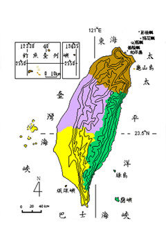
Taiwan is a mountainous island. Mountains account for 30% ofits total area, hills and plateaus for 40%, and plains for the remaining 30%. In terms of altitude Taiwan's topography can be categorized as follows:
A. Mountains
Taiwan's mountainous area consists of mountains of over 1,000 meters, spreading from the east to the central part of the island. Most of the mountain ranges go from north to south. Starting from the east coast, they are: Taitung Coastal Mountain Range (Hai-an Shan-mo), Central Mountain Range (Chung-yang Shan-mo), Snow Mountain Range (Hsue-shan Shan-mo), Jade Mountain Range (Yu-shan Shan-mo), and Ali Mountain Range (Ali-shan Shan-mo). The Central Mountain Range starts at Suao in the north and ends at Heng-chun Peninsula in the south, with a total length of 340 kilometers. It forms the major watershed for Taiwan's rivers. Jade Mountain (Yu-shan), soaring to a height of 3,952 meters, is the highest peak in Taiwan.
B. Hills and Plateaus
On the outskirts of the mountainous area are hills and plateaus ranging from 100 to 1,000 meters in altitude. Most of the hills are located in the west, especially in Chu-nan and Chia-i. They are constantly cut through by rivers and torn apart by faults in the earth's crust. As a result, they form an extremely rugged and broken landscape. Plateaus on the other hand are relatively low and flat, no more than 600 meters in height. All of them are in the west, starting from the Lin-ko Plateau in the north to the Heng-chun Plateau in the south. The soil covering both hills and plateaus in Taiwan has a high quantity of red clay and gravel.
C. Plains and Basins
The lowlands are most often found near the sea and rivers. Land formations lower than 100 meters are plains: these include great plains, deltas and valleys. Those surrounded by hills with a flat base in the center are basins, though some basins rise above 100 meters. The major ones in Taiwan are Taipei basin, Taichung basin, and Puli basin.
D. Coasts
Taiwan's coastline is approximately 1,566 kilometers long. There are four types of coastal landscape based on crust movement, rock formation and the resulting slope and contour of the sea floor as it rises to meet dry land: